A visitor to downtown Salt Lake City might have a hard time
envisioning the early cityscape, perhaps because it was more of a farmscape
than a downtown. Early Salt Lake City was a splattering of single family homes,
often built of adobe. Most of these homes included plenty of yard, trees, and garden
space. There was also a more congested—but small—business district, which ran
along Main Street and spread out to some connecting streets.
Perhaps one of the most difficult parts of Salt Lake’s past
to envision would be Brigham Young’s Downtown Complex. Brigham Young, second
President of The Church of Jesus Christ of Latter-day Saints, owned several
properties and homes (for his numerous wives) in Salt Lake City. The focus of
this post will be the large downtown complex, which included the Beehive and
Lion Houses. For those interested in all of Young’s homes (in Salt Lake, other
parts of Utah, and other homes in the Eastern United States) I recommend
finding a copy of Brigham Young’s Homes,
edited by Colleen Whitley, and published by Utah State University Press in
2002.
While apartments and condominiums now cover the majority of
the property that made up the downtown complex, what remains from Young’s time includes: the Beehive and Lion Houses, the early Church and Territorial Offices, and a
few sections of a huge rock wall that once surrounded Young’s land. The
modern-day Eagle Gate and Brigham Young Historic Park also pay homage to the memory of
this downtown property.
My next several blog posts will explore this downtown
complex; what is gone and what remains.
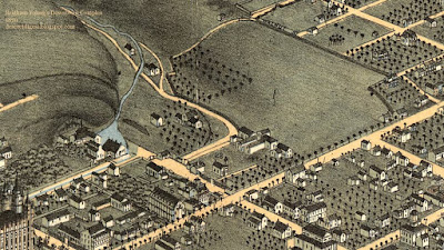
To start, let’s get a basic overview of the complex. Below
are two drawings which are useful in conceptualizing the property. It appears
that each creator took some artistic license creating the bird's eye views—as demonstrated
by the Salt Lake Temple which is shown as completed 20+ years too soon—but the
overall picture is fairly accurate.
 |
Birds-Eye View of
Salt Lake City, Utah Territory, 1870.
Drawn by Augustus Koch.
Digital Image courtesy of the
Library of Congress, Geography and Map Division.
Source: https://lccn.loc.gov/75696611
|
 |
Birds-Eye View of
Salt Lake City, from the North, looking South-East, Utah, 1875.
Drawn and published by E. S. Glover.
Digital Image courtesy
of the Library of Congress, Geography and Map Division.
Source: https://lccn.loc.gov/75696614
|
Young’s complex ran south to north between South Temple to 4th Avenue, and west to east from Main Street to Walnut Street (currently “A Street”), narrowing as it ran north besides City Creek.
Below is a 2016 satellite image of Salt Lake City. The red outline encloses Young’s property as shown in the drawings above. This outline is an approximation only, especially towards the left side of the image. The western half of this block was the Church’s Tithing Office and Yard, and during the nineteenth century it is often difficult to differentiate Church owned property, from property owned by Church leaders.
 |
| Map Data: Google |
Stay tuned for additional posts about the various features of Brigham Young's Downtown Complex.
No comments :
Post a Comment
All comments are moderated before they become visible. Any comments with advertising, trolling, personal attacks, crude language, etc. will not be published. The final say on what gets approved or rejected is reserved for the blog author. Remember any published comments will become public.